Weather & Climate Data

A variety of climate and weather data resources are available from the U.S. Dept. of Commerce's National Oceanic and Atmospheric Administration (NOAA). Key sources within NOAA include the National Centers for Environmental Information (NCEI) and the National Weather Service. NOAA maintains separate Climate and Weather resource pages with links to data and information.
Climate data is tricky because there is so much of it and different stations record different elements and report at different intervals. Also weather stations move over time, which can be a problem for local level anaylses. It is best to verify the location coordinates of weather stations before performing local-level analyses by checking them in Google Earth using address information or other clues.
There is a tiered approach to disseminating climate data in the US:
- State climate offices
- Regional climate centers
- National Centers for Environmental Information - most comprehensive source
- NCEI Data Access - wide variety of download options for environmental data
- US Climate Atlas - online map images, replaces former DVD product
- Global Historical Climatology Network
Depending on your needs, the state climate offices and the Regional Climate Centers may be the best places to go for data. They are usually small operations so often you can actually speak with a climatologist to request what you need, and they are familiar with the data and can best assist you. Also, there may be smaller networks of weather stations in the state or region whose data are not collected by the NCEI. They may or may not charge for data.
PRISM Climate Data
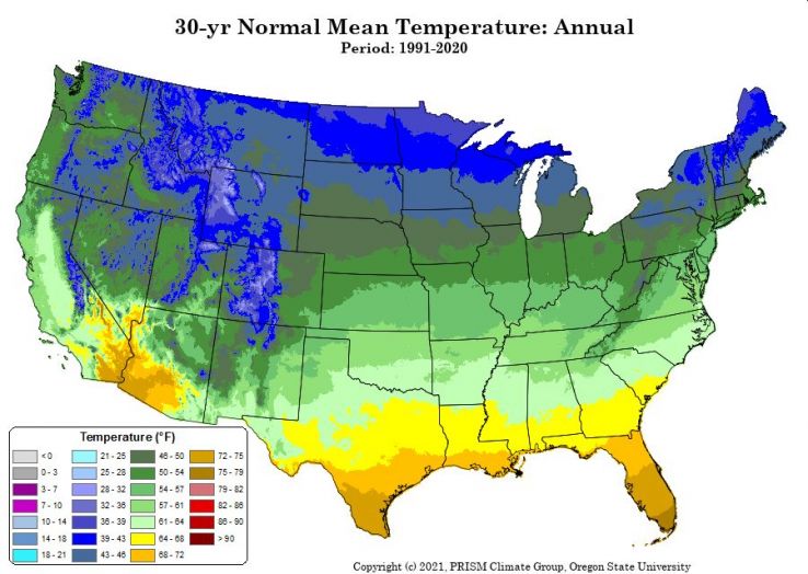 The PRISM Climate Group at Oregon State provides interpolated rasters for the US and territories of precipitation, temperature, and other climate variables, that are well suited for GIS display and analysis. Their most popular product are the 30-year Normals datasets, which are updated every 10 years. By creating interpolated grids, climate conditions for mountainous or rural areas where there are few reporting stations can be estimated.