Rockingham County GIS Data
Feature Data Layers obtained March 2001
The following county-wide feature data layers are available for Rockingham County. The data are in shapefile format, State Plane NAD 83/feet. The data was obtained in Mar. 2001. Time stamps for individual files vary.
Feature Data
The following feature data layers are available and yet to be documented:
Countywide Tiles
- Census Block Groups
- Census Tracts
- Cities
- County
- Parcels
- Railroad Names)
- Soils
- TIGER Hydrography
- Drives
- Centerlines
Map Grid Tiles
- Centerlines
- Hydrography (line)
- Hydrography (polygon)
- Planimetric
- Railroads
The assessors database is also available as delimited text file (taxdata.txt, 19.4 mb)
Digital Orthophotos
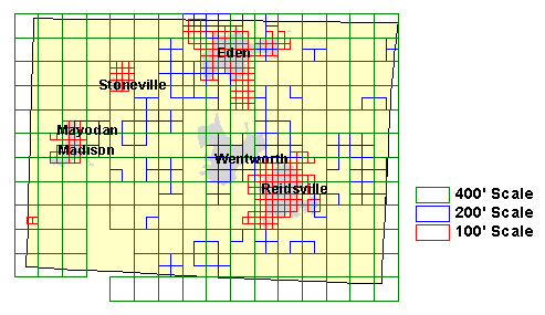
As of 2001, the latest digital orthophoto flights were done Feb., 1998 by ASI. The original data is in TIFF format (not currently available through the Libraries). Data is currently available as 570 MrSID compressed images, about 0.9 mb per image, all at 100', 200' or 400' scale. Six additional 400' scale images appear to be missing currently. Data availability is shown below:

Image index shapefiles (indexall.shp [all images], index100.shp [100' scale], index200.shp [200' scale], index400.shp [400' scale]) for the county is available on the Geodata server at: https://proxying.lib.ncsu.edu/index.php?url=http://gisdata.lib.ncsu.edu/localgov/Rockingham_County/2001/Vector/Disk1/ (data in State Plane NAD 83/feet).
Explore
Library Data Services
Learn About GIS
Can't find data you're looking for?
Contact a Data Services Librarian for help.